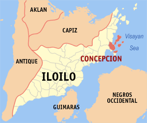
Location Map of Concepcion
The Municipality Concepcion, situated in northern Iloilo, is best known for the 16 scenic islands that occupy a considerable portion of Concepcion. The largest and probably most popular of these islands, is Pan de Azucar (or Sugar Loaf) where Mt. Manaphag (also popularly known as the Mt. Pan de Azucar) stands with its spectacular crags and very steep incline. This majestic mountain is the most commanding landmark in Concepcion since it is the tallest peak in the islands that dot the northeastern coast of Iloilo (2nd tallest in Panay) and is described as the steepest mountain in the country.
By and large the islands of Concepcion are highland masses except Baliguian which is a Coral Reef. They appear as half drowned mountains jutting out from the sea and manifested by sedimentary rocks. The mountain and hill system are so close to the sea that only very narrow strips of level land border the shores where the islanders have built there clustered homes. On the coast of these islands, are unsoilt beaches and diving sites known widely among foreigners and domestic tourists. Fortunately (or the other way around for some), the islands are not yet developed, thus only few accommodations are available. So better bring a sleeping bag, and ample food and water when planning to spend the night in Concepcion.
The coastal portion of mainland Concepcion is an ideal and natural harbor for boats because of the string of islands that surround it. In 1872, the Spanish authorities, taking advantage of the strategic location, set-up a headquarters on an east-side hill. Later, the town became the capital of the sub-province of Northern Iloilo. Spanish galleons, Chinese junks and ships of other countries would call in to trade, make repairs and seek shelters from storms.
Near the end of World War II, a fierce naval battle between Japanese and American forces was staged in the waters of Concepcion. In September 1944, a Japanese transport vessel and a convoy of naval boats were attacked by American air and naval forces and after four days of fighting, not one Japanese vessel remained afloat. Until late in 1960Â’s, the mast of a ship, which tried to navigate through the narrow channels of Pan de Azucar after being attacked, could be seen protruding above the water during low tide.
[Tourism] Concepcion in Focus
- Mt. Manaphag (also called "Mt. Pan de Azucar")
- Located in Pan de Azucar island, it is the most commanding landmark in Concepcion. According to legend, a giant named Toya used to inhabit the summit of Manaphag. Toya takes a bath in a lagoon on the summit, using for a scoop the shell of a gigantic manlot or clam. It is also home to white-breasted hawks and a community of wild monkeys.
- Sandbar Island Beach Resort
- A privately owned 21-hecare island resort that is only 30 min. away from the mainland of Concepcion, Iloilo. It is ideal for swimming, snorkeling, fishing, and just about any water reacreation activity.
- Mt. Apitong
- Site of the PT&T relay station ideal for mountain climbers where they can view the scenic island Panorama of the horizon dotted by several islands and the beauties of the surrounding countryside of concepcion.
- Hampangan Rock
- Located in Tambaliza Island on the top of the mountain near pan de Azucar Mountain, Concepcion.
- Apitong Pass
- Noted for its deep blue sea.
- Tinagang Dagat
- Can be found at the Barangay Plandico, Concepcion where the hidden sea lies.
- Iyang Beach Resort
- One of the best in Northern Iloilo with complete cottage facilities and conducive for seminars and conferences.
- Underground Japanese Garrison
- Can be found at Barangay Bagongon, Concepcion and barracks of the Japanese soldiers during World War II.
- Spanish Well
- Can be found at Barangay Agnaga, Concepcion and still existing up to the present.
- Two Spanish Canons
- Used by the Spanish Soldiers during the Spanish regime, 1859, are still existing and could be found near the entrance of the Municipal town hall of Concepcion.
- Talisay Tree at the Concepcion College of Fisheries
- This "Hanging Tree", where the Spaniards used to hang Filipinos, is the mute witness of Spanish atrocities to the Filipinos
- Punta Bagongon
- Place where Captain Yugis Mohammed Commanding the 64th Infantry assaulted the Japanese soldiers in their garrison and secret barracks.
- Agho Island, Concepcion
- A perfect summer paradise. The island is one of the few uninhabited islands with extensive white sand beach area and a sprawling coral reef located 7 nautical miles northeast of the town.
- Bago-abo Island, Concepcion
- A 2.8 hectare islet is perfect for people who love the underwater world located 3.5 nautical miles from east of the town.
- Bago-isi Island, Concepcion
- A semi-rocky island 7.2 nautical miles north of the town hosting a very small fishing village.
- Chico or Bagosipol Island, Concepcion
- An inhabited islet approximately 4 hectares located 7.2 nautical miles northeast of the town.
- Baliguian Island, Concepcion
- The only coral atoll with cool fine white coral sand coastline located 24.5 nautical miles northeast of the town host of the modern maritime lighthouse managed by the Philippine Coast Guard.
- Bocot Island, Concepcion
- The smallest/uninhabited islet located 8 nautical miles northeast of the town.
- Botlog Island, Concepcion
- Located 4.7 nautical miles northeast of the town proper, it hosts a pearl farm.
- Bolobadiangan Island, Concepcion
- Known for its long white sand dune located 5 nautical miles east of the town.
- Colebra or Bago-alas Island, Concepcion
- The northernmost frontier of Concepcion at 10.7 nautical miles.
- Danao-Danao Island, Concepcion
- One of the most populous islands located 6 nautical miles east of the town proper.
- Malangabang Island, Concepcion
- One of the largest islands located 11 nautical miles northeast of the town.
- Igbon Island, Concepcion
- Another large tract of land mass located 4.5 nautical miles northeast of the town.
- Pan de Azucar Island, Concepcion
- The largest of all Concepcion Islands located7 nautical miles north of the town host to the famed TAMPISAW Festival. It is also home to white-breasted hawks and a community of wild monkeys.
- Sombrero Island, Concepcion
- Appears like a natural citadel of high rise, rocky, protective outreach of Pan de Azucar located 7.3 nautical miles from the town.
- Tago Island, Concepcion
- The nearest island to the town proper is uninhabited due for massive tourism development.
- Tagubanhan Island, Concepcion
- Definitely the most populous island, which straddles between the Municipalities of Ajuy and Concepcion located south east of the town.
- The yearly Tampisaw Festival of the municipality of Concepcion is a celebration of water, the root of life. Concepcion Mayor Dr. Raul Banias said that the festival symbolizes the unending affection of the residents to the sea, which is a primary source of livelihood for them. The Tampisaw Festival is made to coincide with the celebration of Earth Day, which begins on April 22 and culminates on April 24, 2004. Tampisaw is a “home-grown, nature-based” festival, according to ConcepcionÂ’s Tourism Officer Mario Lazarito. The term, which was coined by DOT'’s Helen Camarista, means “to playfully wade in water”. (more)
- Concepcion was originally called Bacjawan, following the native practice of naming places after natural landmarks. The name actually means “the place of the bacjaw trees”, which used to proliferate in wide swampy areas along the coast. (Today, two adjoining barangays west of the Poblacion still carry the Bacjawan name). In 1855, during the Spanish regime, Bacjawan was formally founded as a pueblo, with Felizardo Azucena as its first capital basal or gobernadorcillo. Later, the local Cabesas de Barangay petitioned the Spanish Commandante Enrique Garcia to change the name of the town from “Bacjawan” to “Concepcion”, in honor of the firstborn daughter of Capital Azucena. In 1895, the town was officially known as Concepcion and recognized as a political subdivision of the national government. (more)
View Concepcion's Municipal Profile