Sandbar is a privately owned 21-hecare island resort that is only 30 min. away from the mainland of Concepcion, Iloilo. It is ideal for swimming, snorkeling, fishing, and just about any water recreation activity. courtesy of IAMME from skyscrapercity.com
A unique feature of the island is the shifting white sandbar, which would shift from left to right depending on the direction of the wind. It is also home to Tabon (or "Cover") Birds, named as such because they lay their eggs on the sand where the eggs will be incubated.
Located in Pan de Azucar island ("Sugar loaf"), it is the most commanding landmark in Concepcion. According to legend, a giant named Toya used to inhabit the summit of Manaphag. Toya takes a bath in a lagoon on the summit, using for a scoop the shell of a gigantic manlot or clam. It is also home to white-breasted hawks and a community of wild monkeys. The Mt. Manaphag, also popularly called Mt. Pan de Azucar, is the tallest peak in the islands that dot the northeastern coast of Iloilo and the 2nd tallest in Panay. It is characterized by spectacular crags and a very steep incline, the reason why some consider it the steepest mountain in the country. Thus, it poses quite a challenge for mountain climbers.
Picture courtesy of IAMME from skyscrapercity.com
Sigarong Backpackers, a mountin climbing group, has provided an interesting online journal of their climb of Mt. Manaphag [link]
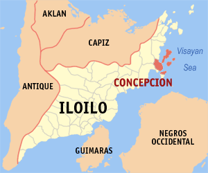
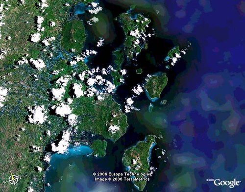
The Municipality Concepcion, situated in northern Iloilo, is best known for the 16 scenic islands that occupy a considerable portion of Concepcion. The largest and probably most popular of these islands, is Pan de Azucar (or Sugar Loaf) where Mt. Manaphag (also popularly known as the Mt. Pan de Azucar) stands with its spectacular crags and very steep incline. This majestic mountain is the most commanding landmark in Concepcion since it is the tallest peak in the islands that dot the northeastern coast of Iloilo (2nd tallest in Panay) and is described as the steepest mountain in the country. By and large the islands of Concepcion are highland masses except Baliguian which is a Coral Reef. They appear as half drowned mountains jutting out from the sea and manifested by sedimentary rocks. The mountain and hill system are so close to the sea that only very narrow strips of level land border the shores where the islanders have built there clustered homes. On the coast of these islands, are unsoilt beaches and diving sites known widely among foreigners and domestic tourists. Fortunately (or the other way around for some), the islands are not yet developed, thus only few accommodations are available. So better bring a sleeping bag, and ample food and water when planning to spend the night in Concepcion.
The coastal portion of mainland Concepcion is an ideal and natural harbor for boats because of the string of islands that surround it. In 1872, the Spanish authorities, taking advantage of the strategic location, set-up a headquarters on an east-side hill. Later, the town became the capital of the sub-province of Northern Iloilo. Spanish galleons, Chinese junks and ships of other countries would call in to trade, make repairs and seek shelters from storms.
Near the end of World War II, a fierce naval battle between Japanese and American forces was staged in the waters of Concepcion. In September 1944, a Japanese transport vessel and a convoy of naval boats were attacked by American air and naval forces and after four days of fighting, not one Japanese vessel remained afloat. Until late in 1960Âs, the mast of a ship, which tried to navigate through the narrow channels of Pan de Azucar after being attacked, could be seen protruding above the water during low tide.
Located in Pan de Azucar island, it is the most commanding landmark in Concepcion. According to legend, a giant named Toya used to inhabit the summit of Manaphag. Toya takes a bath in a lagoon on the summit, using for a scoop the shell of a gigantic manlot or clam. It is also home to white-breasted hawks and a community of wild monkeys.
A privately owned 21-hecare island resort that is only 30 min. away from the mainland of Concepcion, Iloilo. It is ideal for swimming, snorkeling, fishing, and just about any water reacreation activity.
Mt. Apitong
Site of the PT&T relay station ideal for mountain climbers where they can view the scenic island Panorama of the horizon dotted by several islands and the beauties of the surrounding countryside of concepcion.
Hampangan Rock
Located in Tambaliza Island on the top of the mountain near pan de Azucar Mountain, Concepcion.
Apitong Pass
Noted for its deep blue sea.
Tinagang Dagat
Can be found at the Barangay Plandico, Concepcion where the hidden sea lies.
Iyang Beach Resort
One of the best in Northern Iloilo with complete cottage facilities and conducive for seminars and conferences.
Underground Japanese Garrison
Can be found at Barangay Bagongon, Concepcion and barracks of the Japanese soldiers during World War II.
Spanish Well
Can be found at Barangay Agnaga, Concepcion and still existing up to the present.
Two Spanish Canons
Used by the Spanish Soldiers during the Spanish regime, 1859, are still existing and could be found near the entrance of the Municipal town hall of Concepcion.
Talisay Tree at the Concepcion College of Fisheries
This "Hanging Tree", where the Spaniards used to hang Filipinos, is the mute witness of Spanish atrocities to the Filipinos
Punta Bagongon
Place where Captain Yugis Mohammed Commanding the 64th Infantry assaulted the Japanese soldiers in their garrison and secret barracks.
concepcionISLANDS
Agho Island, Concepcion
A perfect summer paradise. The island is one of the few uninhabited islands with extensive white sand beach area and a sprawling coral reef located 7 nautical miles northeast of the town.
Bago-abo Island, Concepcion
A 2.8 hectare islet is perfect for people who love the underwater world located 3.5 nautical miles from east of the town.
Bago-isi Island, Concepcion
A semi-rocky island 7.2 nautical miles north of the town hosting a very small fishing village.
Chico or Bagosipol Island, Concepcion
An inhabited islet approximately 4 hectares located 7.2 nautical miles northeast of the town.
Baliguian Island, Concepcion
The only coral atoll with cool fine white coral sand coastline located 24.5 nautical miles northeast of the town host of the modern maritime lighthouse managed by the Philippine Coast Guard.
Bocot Island, Concepcion
The smallest/uninhabited islet located 8 nautical miles northeast of the town.
Botlog Island, Concepcion
Located 4.7 nautical miles northeast of the town proper, it hosts a pearl farm.
Bolobadiangan Island, Concepcion
Known for its long white sand dune located 5 nautical miles east of the town.
Colebra or Bago-alas Island, Concepcion
The northernmost frontier of Concepcion at 10.7 nautical miles.
Danao-Danao Island, Concepcion
One of the most populous islands located 6 nautical miles east of the town proper.
Malangabang Island, Concepcion
One of the largest islands located 11 nautical miles northeast of the town.
Igbon Island, Concepcion
Another large tract of land mass located 4.5 nautical miles northeast of the town.
Pan de Azucar Island, Concepcion
The largest of all Concepcion Islands located7 nautical miles north of the town host to the famed TAMPISAW Festival. It is also home to white-breasted hawks and a community of wild monkeys.
Sombrero Island, Concepcion
Appears like a natural citadel of high rise, rocky, protective outreach of Pan de Azucar located 7.3 nautical miles from the town.
Tago Island, Concepcion
The nearest island to the town proper is uninhabited due for massive tourism development.
Tagubanhan Island, Concepcion
Definitely the most populous island, which straddles between the Municipalities of Ajuy and Concepcion located south east of the town.
tampisawFESTIVAL
The yearly Tampisaw Festival of the municipality of Concepcion is a celebration of water, the root of life. Concepcion Mayor Dr. Raul Banias said that the festival symbolizes the unending affection of the residents to the sea, which is a primary source of livelihood for them. The Tampisaw Festival is made to coincide with the celebration of Earth Day, which begins on April 22 and culminates on April 24, 2004. Tampisaw is a home-grown, nature-based festival, according to ConcepcionÂs Tourism Officer Mario Lazarito. The term, which was coined by DOT's Helen Camarista, means to playfully wade in water. (more)
[History] Concepcion in Focus
Concepcion was originally called Bacjawan, following the native practice of naming places after natural landmarks. The name actually means Âthe place of the bacjaw treesÂ, which used to proliferate in wide swampy areas along the coast. (Today, two adjoining barangays west of the Poblacion still carry the Bacjawan name). In 1855, during the Spanish regime, Bacjawan was formally founded as a pueblo, with Felizardo Azucena as its first capital basal or gobernadorcillo. Later, the local Cabesas de Barangay petitioned the Spanish Commandante Enrique Garcia to change the name of the town from ÂBacjawan to ÂConcepcionÂ, in honor of the firstborn daughter of Capital Azucena. In 1895, the town was officially known as Concepcion and recognized as a political subdivision of the national government. (more)
Statistics and Information about Concepcion, Iloilo
[Location and Accessibility] Concepcion in Focus
108 kilometers from Iloilo City, it is located in the east of Panay Island and northeast of Iloilo Province. It is Bounded in the east and south by Visayan Sea, in the north by Municipality of San Dionisio and in the west by the Municipality of Ajuy and Municipality of Sara.
[Geography and Political Subdivision]Concepcionin Focus
Concepcion is politically divided into 25 barangays, 14 of which are located on the mainland and 11 in 16 islands scattered throughout Concepcion's waters.
Land Area - 97.02 sq. km. or 9,702 hectares
Area of Territorial Waters - 22.2 sq. km. or 22,200 hectares
Topography - The Mainland of Concepcion follows a lowland upland pattern the Southeastern portion is characterized by thin areas of lowlands starting from the coast giving way to low slightly rolling hills which gradually rise to steeply hills converging at the slopes of Mt. Apitong, Clustered around this mountain are the Barangays of Nipa, Loong, Poblacion, Tamis-ac, Nino, Macalbang and Plandico, covering about 56% of the mainland area. By and large the island of Concepcion are highland masses except Baliguian which is a Coral Reef. They appear as half drowned mountains jutting out from the sea and manifested by sedimentary rocks. The mountain and hill system are so close to the sea that only very narrow strips of level land bordering the shores where the islanders built there clustered homes.
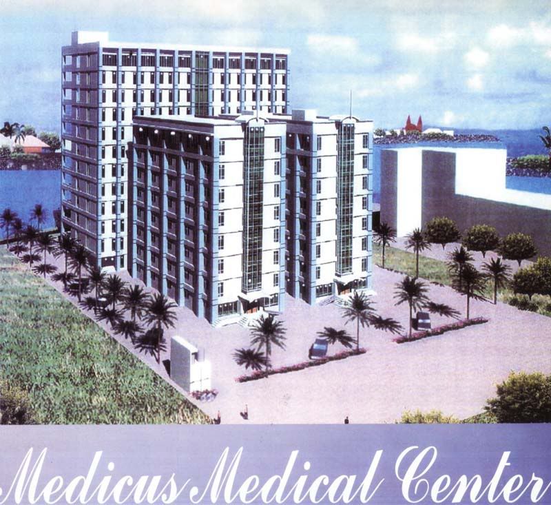
Medicus Medical Center The most modern and complete medical facility in Panay
A high-rise building complex featuring a 12-storey building & 2 eight-storey buildings. It will house the Health Partners Condo-Clinics Featuring ergonomically designed medical clinics built in the fashion of condominium comfort and luxury, the Health Partners Condo-Clinics provide the opportunity for doctors to own their clinic spaces in a building that is secure and assured of quality features and facilities
Features and Amenities * Auxiliary Generator Power Supply * High-Speed Elevator * Computer Hook-Ups * National and International Voice and Data Communication Linkages * Corporate Office Architecture and Interior Design * Patient and Doctor Friendly Environment * 24-Hour Security * Ample Parking spaces * Within 5 minuted from all hospitals, shopping centers and airport
Health Partners Condo-Clinics An easy way to own your clinic and reap additional financial benefits while being part of the Medicus Advantage
Value Plus Benefits: * Operate your clinic in a building equipped with complete and modern medical facilities at an affordable price, while being an investor and co-owner of the Health Partners Condo-Clinics * Turn your condo-clinic unit into an income-generating investment through rental revenues * Become part of one of the leading healthcare companies in the Philippines * Own Medicus shares that have a high Return-On-Investment potential
Jalandoni St., Iloilo City 5000 Philippines Tel #: (033)3372277 Tax #: (033)3372299 email address:centennial.plaza1@skyinet.net
Amenities * Fully Air-conditione spacious rooms * Hot and Cold Shower * 21" color TV with Cable * Refrigerator with Mini-bar / Telephone * FREE National Daily Newpaper * FREE Coffee and Tea with making facility * Bath tub, Receiving Room (suite room) * Jacuzzi Shower, Dining Area, Living Room * Kitchen (presidential only)
Room Classification (as of March 2006) * Free International Buffet Breakfast * Business CLASS Single - P1,090 * Business Class Twin/Mat. Single - P1,240 * Business Class Twin/Mat. Double - P1,430 * Executive Suite Single Occupancy - P1,840 * Executive Suite Double Occupancy - P1,990 * Presidential Suite Penthouse - P5,900 * Extra Bed - P250 * Extra person (no free breakfast) - P150
Facilities * The Buffet Plaza - the first and only all day buffet in Iloilo * Joaqui's The Oyster Bar * Plaza Cafe Lobby Lounge
Function Rooms * Millenium Hall - 250 Person Banquet Hall * Centennial Meetin Rooms - 30-100 Persons
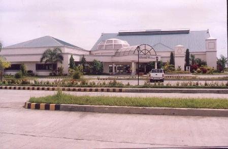
Iloilo Grand Hotel means getting the best experiences all under one roof. Stands at its grandest in Iznart Street. Although Iznart is one of the busiest streets in Iloilo, once you are inside Iloilo Grand Hotel, you will feel far from the hustle and bustle of the city. Iznart Street, Iloilo City Philippines 5000 Tel #: (033) 3351801-04 Fax #: 033-3350456 Globeline: 5099130-31
Corporate Grand Ballroom The biggest Ballroom in Iloilo City where over a thousand guest can be accommodated.
Lobby The receiving area of the hotel where guests can listen to live entertainment music from Monday to Saturday and can be comfortable with the oriental minimalist interior.
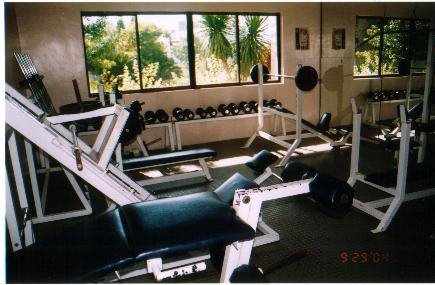
Orient Day Spa & Fitness Center The answer to aesthetic needs with its first class facilities and professionally trained staff .
Cafe Real One of the notable restaurants found inside the hotel. It is right acros the entrance of the hotel where anyone can easily notice an authentic Ilonggo ambiance with the mural of the Calle Real at the left side of the bar.
Services & Facilities
Car Rental City Transport
Banquet and Meeting Facilities
Function Rooms
Business Center
Safety Deposit Box
Major Credit Cards
24 hour Stand-by-1 Generator with ATS
Laundry & Pressing
Elevator Service
Secured Basement Parking
Hot & Cold Water
Bath Tub (Suite Rooms)
21" Colored Cable TV
Massage Services (by appointment)
Orient DaySpa & Fitness Center (2nd level)
Cafe Real (Ground level)
Lumpia house (Ground Level)
Businessman's Suite(Single) - P500.00 Standard (Twin/Mat -) P700.00 Superior - P800.00 De Luxe - P1,000.00 Jr. Suite - P1,500.00 Presidential Suite - P2,400.00 Chairman's Suite - P2,800.00
The LGU Guarantee Corporation (LGUGC) rated the Province of Iloilo "A" (Above Average). Such merit rate indicates that Iloilo has little chance of failing to pay its obligations.
LGUGC is an independent Rating Committee that uses the internationally-accepted LGU rating system.
Such citation is highly considered a value point by under the Local Government Code amidst hard times on budget constraint such as payments of business tax collection shares, real property and business tax among its component municipalities and cities.
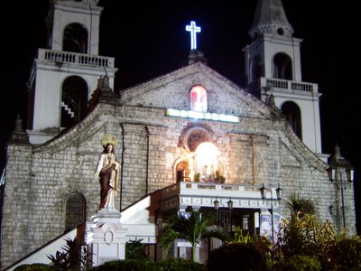
iloiloCHURCHES City Districts Edition Molo Church Its two towering red spires and its regal structure sits on a throne high above the Molo plaza. It is also known to be a feminist church because of the two rows of sixteen female saints line on both sides of the altar. Molo church is very sturdy and has survived fires, earthquakes, and artillery barrages in 1945.
Jaro Church The Jaro Cathedral was built in 1864, the year the district was named a diocese by Pope Pius the IX, by order of His Grace Mariano Cuartero, first bishop of Jaro. A high point in the history of the cathedral was the visit of Pope John Paul VI, conducting a mass in 1982. He set a crown upon the Lady of the Candles, and declared it the Patroness of the Western Visayas.
La Paz Church La Paz, called Lobo, Llaunon or Ilawood, then Iznart after Gov. Manuel Iznart, was a newly established as a parish in 1868. In 1847, Fr. Cándido Gonzáles built a temporary church and convento of wood, bricks and tabique pampango. The present church was constructed from 1870-74. The church is a squat and less elegant version of the San José church in Iloilo. Neoclassic features, and rustication stand in sharp contrast to the bricks used in the church. Two engaged columns supporting a triangular pediment bear the date 1970, apparently recent additions.
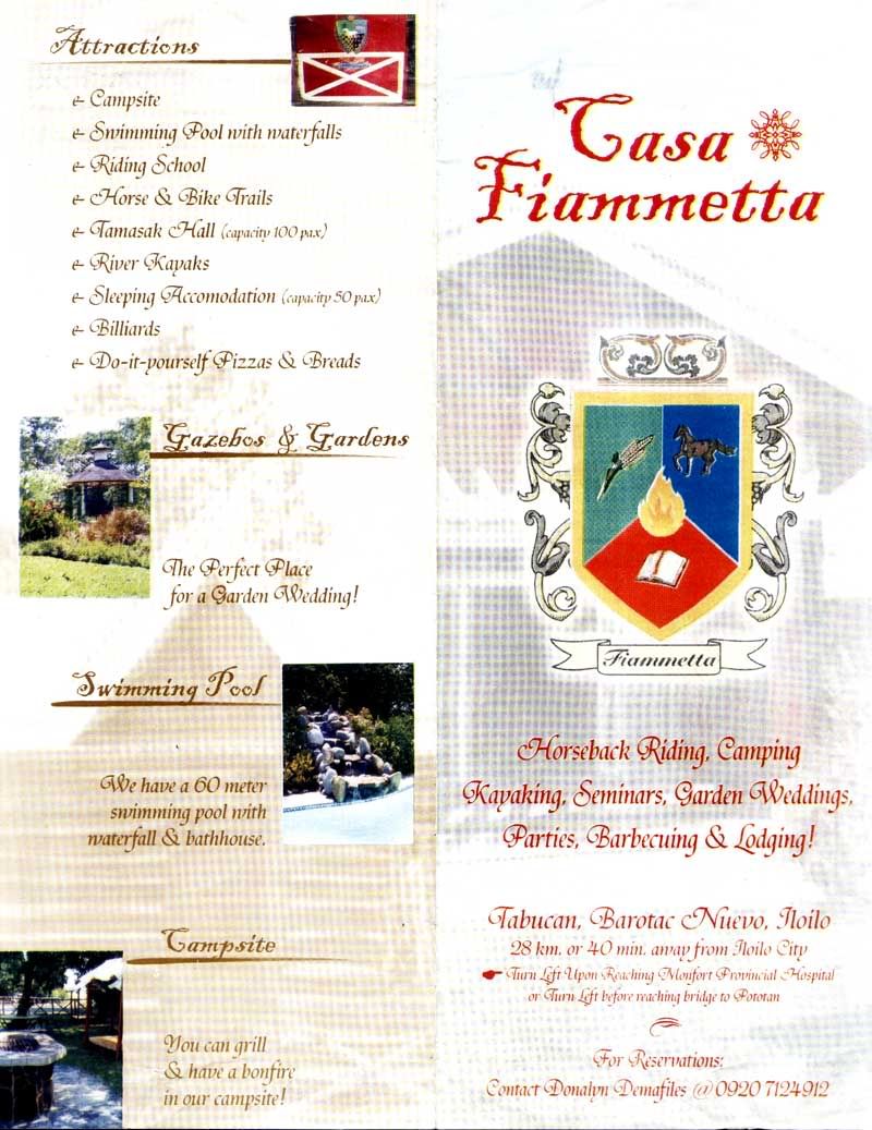
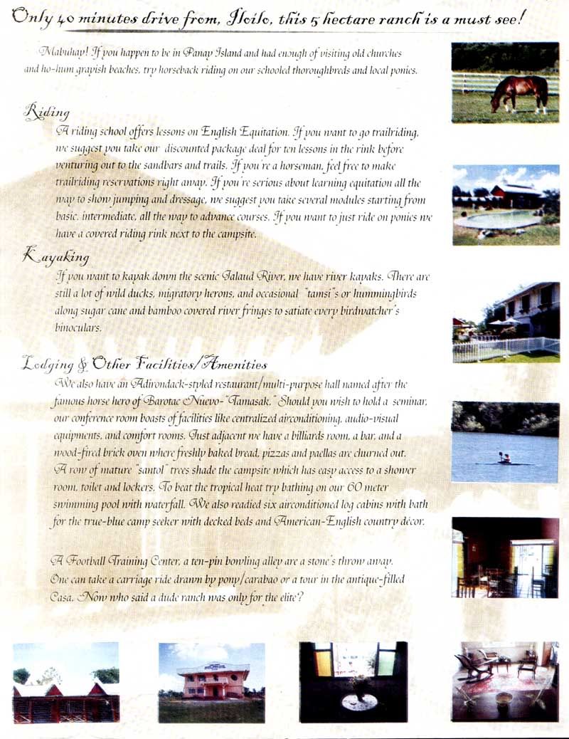
When in Iloilo, try horseback riding on schooled thouroughbreds and local ponies in Casa Fiammetta ,a 40 kilometer drive from Iloilo City at Tabucan, Barotac Nuevo. If you're a horseman, you can make a reservation for trailriding out to the sandbars and trails (beginners can also take lessons in the rink) or if you just want to ride ponies, there is a covered riding rink next to the campside. Aside from horseback riding, Casa Fiammetta also hosts a plethora of outdoor activities like kayaking along the Jalaud River, billiards, swimming, camping, playing football or if you are a bird-lover then bring your binoculars and watch wild ducks, migratory herons, and the occasional "tamsi" or hummingbird along sugarcane and bamboo covered river fringes.
Click the links below to download a brochure of Casa Fiammetta:
Providence-Iloilo boasts of the only, and perhaps the Philippines' first, world-class mass housing community outside of Mega Manila.
Situated in the vicinity of Barangay Balabag, Pavia, Metro Iloilo, it will become the center of a New Urbanism, a design movement now sweeping the globe in its reinvention of the neighborhood concept. Providence Iloilo, designed to have a balance of housing, jobs, and services, aims to fulfill every Filipino family's dream of a secure, accessible, comfortable, and sustainable home and community. It also allows for a variety of choices in home sizes, types and styles made available and affordable for the most discerning in providing for a quality family life. The new urbanism that Providence-Iloilo hopes to promote and live up to is a reinvention of the neighborhood concept which ascertains less automobile traffic by having more people walking than driving. Thus, the discomforts and dangers of speeding and ancillary traffic within the neighborhood is avoided, making streets safer, comfortable and interesting meeting places, as it allows buildings that open onto sidewalks and front porches that invite interaction among neighbors. The concept also includes an ever-wider range of architectural styles that include non-traditional and contemporary approaches to vibrant colors, varying price levels and a range of parks connecting and distributed within neighborhoods.
Providence-Iloilo combines all the essential elements of a complete neighborhood: identifiable center and edge; limited size (commonly 5 minutes walk from center to edge); mix of uses and housing types; interconnected network of walkable streets; and special sites for civic purposes. Its districts generally emphasize a special single use that follows its design. Its corridors serve as regional connectors of neighborhoods and districts; they range from boulevards and rail lines to rivers and parkways. The neighborhood structure of varying housing types, pricing levels, and conservation areas promote daily interaction among people of diverse ages, races, and incomes and lead to stronger personal and civic bonds that revitalize urban centers through concentrations of civic, institutional and commercial activity.
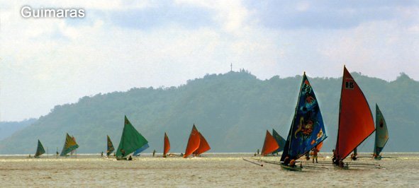
The Paraw regatta is a race among seafarers on colorful sailboats called Paraws in the straits bewtween Guimaras Island and the city of Iloilo. The present-day paraw managed to maintain its original design from the sailboats of the first settlers from Borneo who were in search of a peaceful home in 1212 A.D. Surviving centuries, the paraws have become a vital part of the Filipino seafaring life.
Photo courtesy of www.wowphilippines.com.ph The first race started in 1973 with the mission to preserve the historic value of the paraws. It is held every 3rd weekend of February at Tatoy's Manokan, Sto. Nino Sur, Villa, Iloilo City. Today, the event has grown from being a boat race to a festival with various interesting and exotic activities.
And as Ilonggos take pride of their history and culture, so do the sailors and the boatmakers who have inherited a legacy that became synonymous to the birth of a province and the Hiligaynon-speaking region of the country. Included in the yearly celebration is the Pinta Paraw, where sails are painted by profesional and amatuer artists a day before they actually take off to sail. Another fascinating event is called the Pintawo body-painting contest.
Miss Paraw, Beach Volleyball, and Paraw Regatta Photo Competition are the other events included in the celebration. Also, one of the highlights of this sea festival is the Iloilo Governor Fishing Contest, a campaign against dynamite fishing.
Come to Iloilo and marvel at the sight of colorful paraws!
Pintados de Passi has quite some achievements over the years, consistently winning in the Dinagyang Festival. Just last year, they were the overall champions in the Aliwan Festival or "The festival of festivals" in Manila besting out the other top festivals in the country.
One of the competing tribes during the Ati-ati contest of the Dinagyang Festival 2006. Someone managed to take a video of this tribe's performance, so kudos to you vanz1925, there aren't many Dinagyang footages online
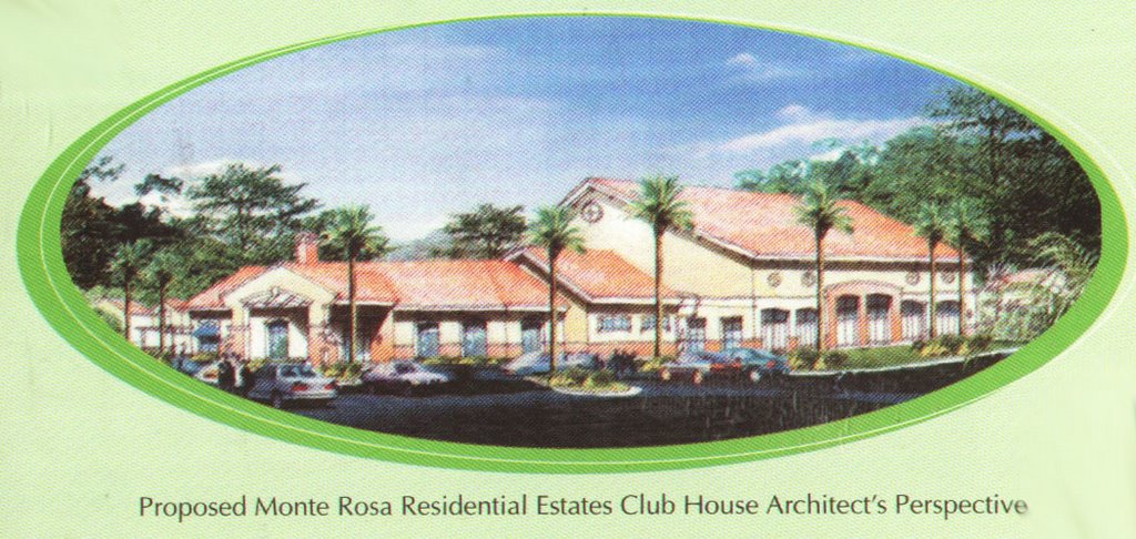
Monte Rosa Residential Estate is a community set apart from the rest. Imagine a master planned suburban community that integrates all the key elements to make your home a refuge. Yes, our community ambiance promises to make you want to spend more time at home.
Monte Rosa is a 57 hectare subdivision located in Brgy. Hibao-an in the quiet district of Mandurriao. Let Monte Rosa transport you into a tapestry subtly interweaving the Hispanic flair and functional designs of the West, a blend of rich Spanish - American country living with a cosmopolitan flair. Truly, the reward of the bourgeoisie when at home in Monte Rosa. Click Picture to Enlarge
Monte Rosa Residential Estate is the second residential development of Sta. Lucia Realty in Iloilo City. It is less than 15 minutes away from the city proper and is conveniently located near schools, hospitals, malls, restaurants and only five minutes away from the airport.
It is a prime real estate with the best features and amenities in the area such as a fully-landscaped entrance gate with guardhouse, an underground drainage system that guarantees no floods! Fully concrete roads, curbs, and gutters, complete electrical facilities, centralized water system and complete with recreational facilities like a swimming pool, an indoor basketball and tennis court.
For more inquiries email carlcaratao@yahoo.com or call 321-0626. The developer
Sta. Lucia Realty & Development., Inc's (SLRDI) group of companies distinguishes itself as a direct contributor to the improvement of the country's economy and its people.
SLRDI has been in the real estate business for more than 30 years and is considered the country's leading horizontal developer with Exequiel D. Robles as Chief Executive Officer and Vicente Santos as Executive Vice President. Sta. Lucia Realty is now considered the biggest real estate company in terms of combined land area, with its prodigious developments rising all over the country.
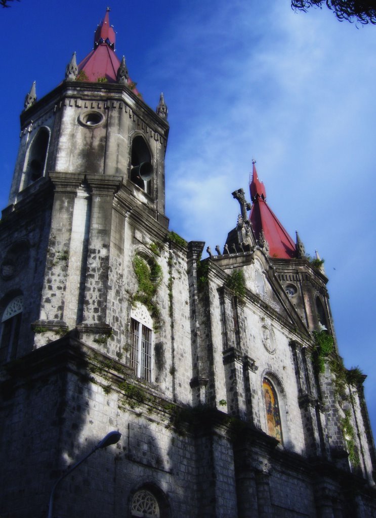
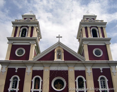
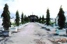
One of the oldest landmarks in the town, constructed in 1845. Its facade bears Spanish influences and is one of the stongest structure built during the Spanish time, surviving the test of earthquakes. It is located at Sitio Anggasan, Barangay Duyanduyan.
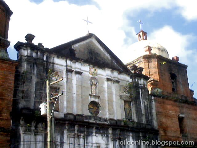
(photo source) This church, of Baroque Rennaisance architecture, was built in 1845 and was completed 33 years later. In 1898, it was made as the general headquarters and military hospital of the revolutionary forces called "Ejercito Libertador" against Spain in the Visayas. The National Historical Institute declared it as a national historical landmark, in 1991.
Statistics and Information about Santa Barbara, Iloilo
[Location and Accessibility] Santa Barbara in Focus
Janiuay is located 15.7 km north of Iloilo City, accessible by any land transportation with the presence of a national highway, provincial, municipal and barangay road networks cutting and criss-crossing its environs.
[Geography and Political Subdivision] Santa Barbarain Focus
Santa Barbara is politically subdivided into 60 barangays
Land Area - 7,750 hectares or 77.5 sq. km.
Topography - varies from slightly rolling hills to an almost flat or gradually inclined plains, sliced by Tigum River at its centermost, which flows from northwest to the southeast and the Aganan River in the southern section.
Santa Barbara's landscape is dotted with many scenic landmarks, of historical value not only to Iloilo but to the whole country as well. Its church, declared by the National Historical Institute as a national historic landmark, was made the headquarters of the revolutionary forces against Spain. And in November 17 1898, its plaza became the site where the Philippine flag was first raised outside Luzon, the event is popularly known as the "Cry of Santa Barbara". Santa Barbara is also known as a "sport-oriented" community for producing world class athletes like Inocencia Solis ( Dubbed as the fastest woman in Asia during the 50s), Jimmy de la Torre ( Asia's marathon king and Santa Barbara's first internationally acclaimed runner). Santa Barbara is also known nationwide for it is the town where football is. It has produced the first Mr. Football, the late Julio G. Umadhay Jr., of the Philippine Navy.
Furthermore, the oldest golf course in South East Asia is located in Santa Barbara. It was founded in 1907 by 13 Scots who worked at the Philippine Railways then.
Today, it is one of the most promising towns in Iloilo for being the site of the new Iloilo airport set to open in 2007. Although at a standstill until the new airport starts operations, local and national businessmen are already slowly moving and planning on how they will ride the inevitable "boom" the town's economy will be experiencing.
[Tourism] Santa Barbara in Focus
Roman Catholic Church and Convent - This church, of Baroque Rennaisance architecture, was built in 1845 and was completed 33 years later. In 1898, it was made as the general headquarters and military hospital of the revolutionary forces called "Ejercito Libertador" against Spain in the Visayas. The National Historical Institute declared it as a national historical landmark, in 1991.
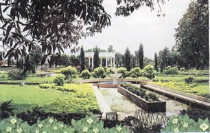
Victory Plaza and Bandstand - the town plaza with its beautiful landscape and the Municipal Bandstand, constructed in 1925, it has served as a stage for band and musicians, political rallies, religious program as well as cultural shows and contests since American era. (photo source)
Cry of Santa Barbara Marker - A historical marker standing in the same site where the Philippine flag was first raised outside Luzon in November 17, 1898. The event is popularly known as the "Cry of Santa Barbara."
Iloilo Golf and Country Club - The oldest existing golf course in South East Asia. Built in 1907 by a group of Scots, English and American expatriates, who were working in the Panay Railways. The Sta. Barbara Golf Course started as a 9 hole golf course carved from the rolling hills of Sta. Barbara. Today, it is a full A challenging 18 hole golf course (6,056 yardage) nestled in the hills of Sta. Barbara, Iloilo., and plays to a par 70 (more info).
Monument of General Martin T. Delgado - Found in the northwestern entrance of the town plaza and facing the municipal building stands the statue in bronze of the town's most distinguished son, Gen. Martin T. Delgado. He is the foremost hero of the revolution against Spain in the Visayas as the commander-in-chief of the revolutionary forces in the these region which drove out the colonizers from the Visayan Islands on November 24, 1898.
Centennial Giant Flag - One of only five giant flags that mark the national trunk sites during the celebration of Philippine Independence in 1998.
Centennial Museum and Information Center
Roman Catholic Cemetery- It is one of the oldest landmarks in the town, constructed in 1845. Its facade bears Spanish influences and is one of the stongest structure built during the Spanish time, surviving the test of earthquakes. It is located at Sitio Anggasan, Barangay Duyanduyan.
Santa Barbara Irrigation Dam - Erected in 1926, the irrigation dam located at Brgy. Tungay is the first gravity irrigation dam in Iloilo. It serves as water supplier of rice fields in Barangay Miraga, Agutayan-Lupa, Lanag, and Cabugao as well as other barangays in Pavia and Leganes, Iloilo.
MIWD Reservoir - Constructed in 1925. The first waterworks system reservoir in the Visayas and Mindanao.
[Kahilyawan Festival and Cry of Santa Barbara] Santa Barbarain Focus
The Cry of Santa Barbara is an annual celebration commemorating the historic event that transpired in the town more than a century ago whereby local folk hero Gen. Martin Teofilo Delgado led the uprising against the Spaniards to free the Visayas and Mindanao.
Kahilwayan it is a cultural festival in a dance-drama from which will showcase the events that led to the historic uprising of the Ilonggos against Spain to its ultimate cry of victory and freedom known to us now as the Cry of Santa Barbara. The Kahilwayan Festival aims to depict the story of the Cry of Santa Barbara in a manner which can bring more color and meaning to the event itself and to draw the interest not only of the people of Santa Barbara but that of other places as well. This is one major way also to develop the tourism industry of the municipality.
Tribu Kahilwayan is a fledgling tribe composed of students from Santa Barbara National Comprehensive High School and Cadagmayan National High School. The tribe itself springs from the groups that competed in the Kahilwayan Festival of the Cry of Santa Barbara celebration, the debut presentation of which was last November 17, 2001. During the Dinagayang 2002 Festival, Tribu Kahilwayan participated for the first time in the Kasadyahan competition and to the surprise of almost everyone, it was declared the grand champion. It also earn three special awards -- best in choreography, performance and costumes. In 2005, Tribu Kahilyawan also joined as Western Visayas' contingent in Manila's Aliwan Festival (the festival of festivals in the Philippines) where it won 2nd place next to another Ilonggo contingent, Pintados de Passi, and ahead of yet another Ilonggo Contingent, Tribu Silak of the infamous Dinagyang Festival.
[History] Santa Barbarain Focus
History of the Municipality of Santa Barbara covers four centuries. According to the Agustinian Archives, Vols. 1718, which records the documents on the missionary achievements of the Agustinians missionaries, it bares the historical note that as early as 1617, the missionaries attended to the spiritual ministration of a community or "pueblo" then known as Catmon. The name was derived from a fruit –bearing tree, which served as an imposing landmark in the vicinity. Its total population at the time was 15,094. In 1845, its inhabitants reach a total of 19,719 and covering an area which are now the Municipalities of Zarraga, New Lucena and a part of Leganes and Pavia.
The Revolutionary Government of the Visayas was organized and on November 17 1898, was formally inaugurated at the town plaza of Santa Barbara. A large crowd of people gathered from many places in Iloilo for the historic occasion. The Filipino flag was raised for the first time outside Luzon. The Revolutionary Government Officials were inducted into office and presented to the people who loudly hailed them.
Sta. Barbara became the base of the Revolutionary forces and from here Gen. Delgado launched the campaign to liberate the whole province which culminated in the surrender of Iloilo city by governor-general de los Rios on December 24, 1898.
At the establishment of the civil government Martin Delgado was appointed the first provincial governor of Iloilo and was elected to the same position in the first elections held in 1903. The town began to progress. Better roads and bridges were built that linked Sta. Barbara to the city and other neighboring towns. The railway line between Iloilo and Capiz built in 1906 passes through the poblacion. Sta. Barbara Golf Course – the first in South East Asia was established in 1907 by a group of Scot, English and American expatriates working in Iloilo business.
World War II brought destruction to whatever little progress that were achieved during the Commonwealth period in Sta. Barbara. Only the Roman catholic Church and the Convent, the Elementary school building was spared as they were utilized by the Japanese as garrison. Life was hard for the residents of the poblacion. The town was finally liberated from the Japanese in 1945 with the help of the Americans. Civil government was restored. The last decade of the 20th century ushered in a new form of governance for the local government units. (full version)
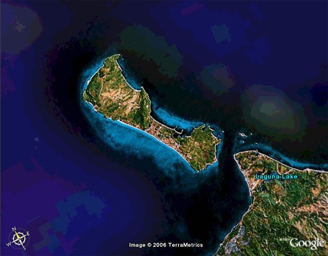
Boracay is a paradise for certified sun-worshippers all over the world. In fact, local and foreign tourists have made Boracay their yearly destination. Others have chosen to live on this haven
Sheltered from the fierce easterly typhoons, Boracay can be found on the northwestern tip of Panay in Aklan, a province on the Visayas island known for its Ati-atihan Festival. Boracay's thousand-hectares boast of all the elements of a tropical haven - crystal blue waters, powder white sand, liberal doses of tropical palms and flowering plants, and a healthy and diverse marine life.
Boracay has three little communities- Yapak in the north, Balabag in the middle, and Manoc-manoc in the south. Hilly elevations of up to 100 meters above sea level characterize Yapak and Manoc-manoc. Intertwining trails alike the small villages and may sometimes lead to lush tropical jungles.
The culinary fare at Boracay is diverse as the nationalities of its visitors. French, Chinese, Australian, Belgian, German, Spanish, Italian, Japanese, Korean, and Thai -- are all fused into the native cuisine. Truly, Boracay has become the premiere destination of beach lovers around the globe
How to get there
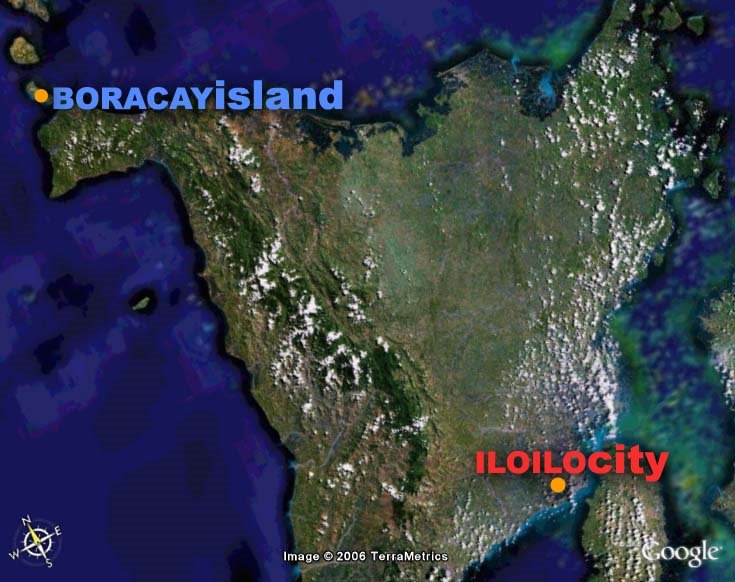
Although there are flights direct to Catican (Main Entry Port to Boracay) and Kalibo (Capital of Aklan). Most tourists prefer using Iloilo's Airport as a gateway to Boracay because they also want to enjoy the unique Iloilo experience along the way. From Iloilo, tourists usually commute via air conditioned buses to Caticlan.
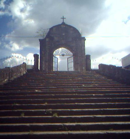
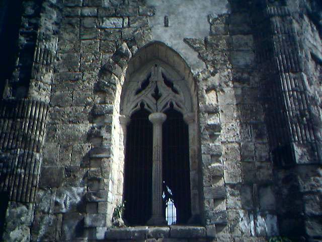
Janiuay Cemetery definitely deserves its fame... a neo-gothic cemetery which was considered to the most artistic cemetery at the time it was finished. The stairs leading to the stone arches are still breathtaking until now. Along the highway connecting Janiuay to the neighboring town of Mina is a cemetery built on a slope. The builder of this cemetery was Fr. Fernando de Llorente who commenced work in 1874 and completed the whole project after nine years. The archbishop of Manila, Pedro Payo, blessed the cemetery.
Back then, when the small cemetery was not able to occupy the tombs, people recklessly built their tombs outside the stone arches making the beauty of the the cemetery fade.
Gothic features that remain are still stunning--the windows pierced by delicate stone tracery, the spires rising at the eight points of the octagonal building.
Janiuay is located 33 km northwest of Iloilo City.
[Geography and Political Subdivision] Janiuayin Focus
Janiuay is politically subdivided into 33 barangays
Land Area - 22,370 hectares or 223.7 sq. km.
Land Use (predominantly agricultural)
Build-up Area - 492.80 hectares
Agricultural - 13,930.00 hectares
Agro-Industrial - 12.30 hectares
Military Reservation/Hospitals - 2.40 hectares
Military Reservation/Hospitals - 2.40 hectares
Pasture/Open Grassland - 1,828.20 hectares
[People] Janiuayin Focus
Population - 54,166 (2000 Census)
Households - 10,322
Dominant Religion - Roman Catholic
Dialect - Kiniray-a, Hiligaynon
[Economy] Janiuayin Focus
The town of Janiuay, Iloilo has recently identified abaca or locally known as Âlanot as its chief product under the One Town One Product (OTOP) program. OTOP is a priority program of the administration of President Arroyo to promote entrepreneurship and create jobs (read more).
With its many areas of historical significance, visitors of the town Janiuay will surely get the real sense of its rich history. One such example is the Janiuay Church ruins, an edifice of a beautiful church between in 1830 to 1871, and the Janiuay Cemetery, a Hispano-Filipino Cemetery dating back to 1884. It is reknowned for its architectural graneur and was once featured in the pages of the National Geographic magazine.
Built on a slope, the Janiuay Cemetery is one of most artistic cemetery in the whole Philippines as described at the time it was built by Fr. Fernando de Llorente who commenced work in 1874.
Situated at both sides of the Suage Bridge, it stands in testimony of the violent attacks launched by the Japanese during World War II.
Igbiating Waterfalls
Located 27 kilometers from the Poblacion in Brgy. Barasalon
Punong
Two Big stones blocking the Suage River, as high as a 3 storey building. A perfect spot to camp and watch a breath taking view of Janiuay.
[History] Janiuay in Focus
In the summer of 1578, the natives of Tala-ugis trudged up from the coast to establish a settlement northward in the interior along Suage River. The first settlers were led by families of Gamuk, Hutikon, Uganet and Pagdakton, who settled themselves in what is currently known as barangays Matag-ub, Danao, Yabon and Quipot.
More than a century later, Spaniards came along these parts of Panay.
Early in 1738, Datu Buhawi of Yabon recognized the Spanish government, thus subjugating himself and his barangay to Spanish rule. But, Datu Dumagtol of nearby Ubian refused to follow suit. He led his subjects to the mountains to resist against the Spanish colonizers.
The Spanish governor Francisco Bayot de Ocampo recommended to the Principalia to transfer the seat of government, and in the following year (1770), the settlements were strengthened in their administration in what they called "Janiuay".
There are two legends of how the place got its name. One is that it came from the ruling Datu's sons named "Han" and "Oway". Another is that the words "hani" (whisper) and "oway" (rattan) were combined.
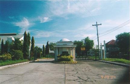
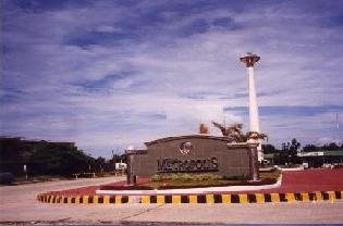
The Metropolis, a unique modern complex blending modern conveniences such as a commercial complex, a bus terminal, a school, and a world of recreation, with the enchanting countryside setting.
Iloilo is the magnificent backdrop, along with the Ilonggo spirit of fun, and familial pleasure, for The Metropolis Residential & Commercial Estates.
Integrated with a complete sports complex, The Metropolis has grown alongside a booming town. Majestic Metropolis Tower stands like a sentry to welcome you and your family at the grand entrance.
Features & Amenities
THE RESIDENTIAL ESTATES
The Metropolis Residential & Commercial Estates is divided into 5 exclusive villages, namely:
• The Metropolis Centre • The Metropolis North • The Metropolis South • The Metropolis East • The Metropolis West
Each village has a separate landscaped entrance gate and guard-house, perimeter wall, and exclusive park and playground.
• 10- to 12-meter wide Concrete Roads • Paved Sidewalks with Promenade Shade Trees • Concrete Curbs and Gutters • Complete Electrical Facilities • Concrete Electrical Posts with Street Lamps • Centralized Interrelated Water System with Overhead Tanks • Underground Drainage System • Located Guimaras Strait 20-meter wide Main Avenue
THE COMMERCIAL AREA
• Commercial Strips throughout the Main Avenue • Grand Rotunda Tower
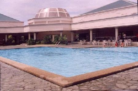
THE SPORTS & RECREATIONAL COMPLEX
• Grand Clubhouse
• Banquet Hall • Lobby • Office • Kitchen • Bar • Gym for Men and Women
• Olympic-type Swimming Pool with Slides • Covered Basketball Court • Covered Tennis Court • Open Tennis Court
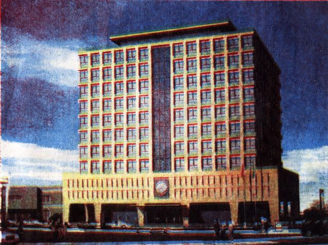
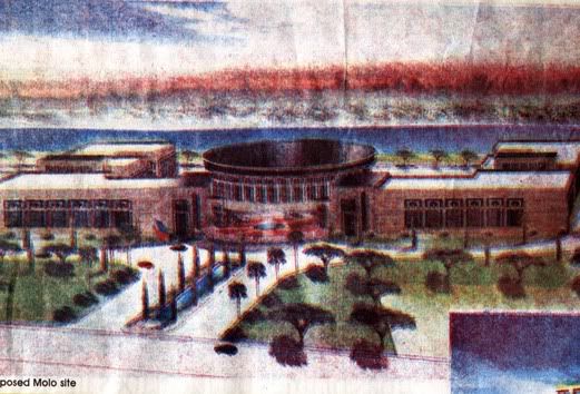
While the final site of the Iloilo City Hall has not been decided yet between the present site of the city hall in downtown or the acquired lot in Molo, the architect (WV Coscoluella and Associates) has already sent the perspectives for both sites to help city officials with their decision making.
The total cost of the project is projected to amount to P320M. Construction will start in 2007
Proposed 2,000 sq. m. Downtown Site. Features a 9 storey building with additional 2 floors for underground parking and a penthouse
Proposed 16,000 sq. m. Molo Site. Features an expansive 2-floor building with a helipad
Strategically located just 3.3 kilometers away from Jaro Plaza, the 100-hectare master planned real estate is proximate to Iloilo City’s major attractions such as colleges and universities, commercial and business areas, hospitals and government centers, air and sea ports. The Jaro Grand Estates integrates several land uses into a singular development. When completed, it will feature its own commercial and restaurant strip, office and business center, hotel and tourist center, university area, and five Caribbean themed residential villages.
Among the modern facilities and amenities envisioned are a modern road network system highlighted by a 20-meter wide main road, several landscaped parks and mini-parks, a central park with amphitheater, a Caribbean themed grand clubhouse with multipurpose courts and playgrounds, paved walkways and covered courts, underground water and storm drainage system, celebrated entrance gates for each of the five subdivisions, and a unique land mark entry.
The first Phase of Jaro Grand Estates is Chateaux Geneva, a 10-hectare middle class residential estate. Development in 2002 and will be completed by the second half of 2004.
It offers 421 lots with cuts ranging from 120 to 250 square meters. There are six Victorian detached house models featuring one, two and three bedrooms with floor areas ranging from 45 to 96 square meters.
The second of five exclusive residential communities of Jaro Grand Estates, the proposed Coastal Villas is a 9-hectare Caribbean village located within the township development. It will feature around 395 lots with cuts ranging from 120 square meters to 192 square meters. There are three Caribbean house models with the smallest at 79 square meters to the biggest 117 square meters, all single-detached. Construction of Coastal Villas will commence by the second half of 2004.
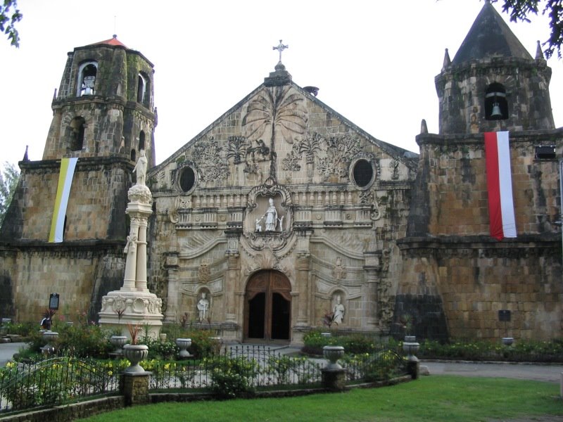
Miagao is best known for its beautiful fortress-church (declared as a World Heritage Site in 1973) built more than 200 years ago. It is also known for being the seat of the University of the Philippines in the Visayas,the symbol of academic excellence and growth in the region, and the hometown of many successful professionals and overseas Filipino workers , whose elegant mansions characterize the Miagao coastline and inland areas. Miag-ao is a must see when visiting the city and province of Iloilo. How it derived its name has several versions. Firstly, it was believed that the word Miagao came from the name of a plant that grew abundantly in the place called "Miagos". Secondly, it was derived from the name of an old Negrito called Miyagaw who when asked of the name of the place by the Spaniards, gave his name instead. The Spaniards mistook with the answer as the response to their query. There is a third version, which relates that the name Miagao came from the love story of two young lovers Maya and Gao.
[Tourism] Miagao in Focus
Miagao Church
constructed more than two hundred years ago in the year 1797, the Miagao Church stands as a living legacy of the culture and way of life of the people of Miagao centuries ago, anchored in a strong foundation of Christian faith.
Salakayan Festival - First festival born outside of the City of Iloilo
Sinuhutan Cave
A magnificent cave located in Barangay Onop, an upland barangay in the municipality.
Tinagong Dagat
A wonderful and mysterious lake located at the peak of the hill.
Kuta Watch Stone
A watchtower constructed with the same material as of the Miagao Roman Catholic Church located at Barangay Baybay Norte, Poblacion.
Old Taytay Boni Stone Bridge
Constructed with the same material as of the Miagao Roman Catholic Church located at Barangay Igtuba.
Bugsukan Cave
Accessible and unspoiled waterfalls with fresh and clear running water located in Barangay Dalije.
[Location] Miagao in Focus
It is situated 40 kilometers Southwest of Iloilo City and 58 kilometers from San Jose, the capital town of Antique. Overlooking the island of Negroes towards South China Sea, Miag-ao is bounded by the towns of Igbaras to the Northeast, by Guimbal to the East, by San Joaquin to the West and by Sibalom, Antique to the Northwest.
Located at the First Congressional District of Iloilo
[Geography and Political Subdivision] Miagao in Focus
Miagao is politically subdivided into 119 barangays.
Land Area - 15,722 hectares or 157.22 square kilometers
Land Use
Agriculture - 52.3%
Built-up / mixed-used - 21.3%
Forest Land - 20.3%
Open Grassland - 6.1%
[People] Miagao in Focus
Population - 57,092 (2000 Census)
Households - 10,898
Dominant Religion - Roman Catholic (90%)
Dialect - Kiniray-a, Hiligaynon
Miagao became an independent Municipality in 1716. It used to be a part or arrabal of four (4) different towns. Record shows that before Miagao became a town, it was an arrabal of Oton until 1580; of Tigbauan until 1952; of Suaraga or Suaragan (now San Joaquin) until 1703; and of Guimbal until 1716 when it became an independent town. It was until 1731, however, when Miagao had its own head. (Full Version)
[Economy] Miagao in Focus
Income Classification - 3rd Class
Income - P51 M (FY2003)
Agriculture
Miag-ao is basically an agricultural town with rice production as the primary crop. Yellow and White corn are considered as secondary crops while mongo, peanuts, bulbs, onions, tomatoes, eggplants, and root crops are also produced as alternate crops.
Fishery - Bangus and other species fry, varied speciesof adult fishes.
Livestock - Cattles, Carabaos, Hogs and Swines, Goats and Poultry.
Major Industries
Aside from agriculture, many are also engaged in salt making, bamboo craft, pottery making, loom weaving, candy making, fish preservation, peanut products processing and fishing.
[Education] Miagao in Focus
Literacy Rate - 96%
University - 1
University of the Philippines in the Visayas [UPV] Miagao Campus
The Miagao campus of the University of the Philippines in the Visayas (UPV) lies on a sprawling 12 km² of gentle sloping hills. This is the main campus of UPV and includes the UP College of Fisheries and Ocean Sciences which focuses on aquaculture, fish processing, natural products development, and post-harvest/food science majors. In the late 1970s and early 1980s, Thailand and Cambodia sent exchange students to the school to study fish and rice production, and after graduating returned home where they began out-producing and out-exporting the Philippines in these commodities.
College- 1
Western Visayas College of Science and Technology Miagao Campus
High School
Public – 5
Kirayan National High School ,WVCST Miagao Campus/SIPC Laboratory High School, Alejandro Firmeza Memorial National High School, Palaca-Damilisan National High School, San Rafael National High School and Miagao National High School [MNHS]
Constructed more than two hundred years ago in the year 1797, the Miagao Church stands as a living legacy of the culture and way of life of the people of Miagao centuries ago, anchored in a strong foundation of Christian faith. In Baroque-Romanesque style, the church sinks six (6) meters deep into the ground with walls one-and-a-half (1 1/2) meters thick and buttresses thrice thicker in size. A truly 'Philippine Church', it exudes a native touch. Its artistic facade is decorated with a relief sculpture of St. Christopher carrying the Christ child amidst coconut, papaya and guava shrubs. A large stone image of St. Thomas of Villanova, parish patron saint, dominates the center. Carved life-size statues of the Pope and St. Henry with their coat-of-arms above them flank the main entrance. Supporting the facade are the twin belfries, one towering two-storeys and the other three-storeys high.
Like any other foreign influences, the architecture of many colonial churches has undergone the process of indigenization. This process is carried out by incorporating the prevailing Hispano-American and Medieval Spanish architecture with local as well as Muslim and Chinese touches. Thus, the synthesized topology which is anachronistic with the unmindful sues of decorative elements. It had no distinction in terms of periods or orders. Stability and massiveness along with durability associated with sound architecture, was very common. Thus, mission churches were mostly fortresses built for military purpose with some concessions on their facades.
The creative and aesthetic abilities of Spanish colonizers are reflected in many colonial churches in the Philippines. This is especially true in Miagao Church - a world-renowned religious structure now included in the UNESCO World Heritage List.
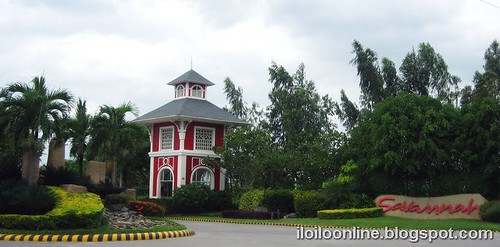
SAVANNAH is a community within a bigger community, with designated areas for a proposed school, a proposed commercial area, areas for the amenities, tree parks, pocket gardens and children’s playground within each of the subdivisions, and provisions for basic utilities such as electricity and water supply. SAVANNAH was conceptualized as a master planned community. With the help of Arch. Felino Palafox, Jr. and Associates, SAVANNAH was designed to be a complete and self sustaining community in the future, the first of its kind of subdivision real estate development in Iloilo.
The homeowners, visitors and guests are warmly and grandly welcomed by its impressive and unique main entrance highlighted by the monumental and majestic Victorian styled tower. One can also enjoy looking at the play of colors of its surrounding landscapes meticulously designed and implemented by the famous landscape designer Arch. Francisco del Velasco.
Projects in SAVANNAH include: (for house and lot and pricing click the links provided)
The life you've always looked forward to awaits you here in the scenic grasslands of Polo, Maestra Vita, Oton. Accessible through Jibao-an, Pavia, Savannah Trails spans 30 hectares of the refreshing countryside.
Savannah Glades
Four years ago, CROWN ASIA, the leading nationwide master planned developer, made a daring and bold move when it launched its 17th subdivision project in Oton, Iloilo, popularly known as SAVANNAH.
CROWN ASIA has more plans for the development of SAVANNAH and for its homeowners and buyers, continuing to raise the standard of subdivision development and lifestyle, a benchmark for the others. Four years hence, there will be more to see at SAVANNAH.
For more inquiries email carlcaratao@yahoo.com or call 321-0626 and look for Carlene.
Built of gray stone, the Cabatuan cemetery was built by Fr. Juan Porras and was blessed on 4 February 1894. It is the only extant Spanish cemetery in the Philippines that is a perfect square. It is enclosed on all four sides by a solid limestone base with artistically-designed steel railing.
Cabatuan Cemetery is the most maintained cemetery in the province. Facing the road to the poblacion, it has three entrances which were said to be the most simplest yet more realized versions of the neighboring cemeteries. The overall design is Romanesque with Gothic rosettes carvings, there is a huge octagonal baroque mortuary chapel or capilla at the center which was beautifully restored.
The Pototan Plaza is arguably grandest plaza in Iloilo. Not only is it graced with an obelisk, a lagoon, a historical marker, a skating rink, stately mahogay and Indian trees, expansive and well maintained greens, it has the Pototan Astodome to crown the town's ascendancy over all other.
It was first conceived by Cong. Licurgo Tirador in 1992 but was completed in 2006 due to fiscal adjustments. The total cost of the project amounted to P45,645,000. It's features include:
As a basketball court, the facilities of the complex are all first class and up to international standard. The wood parquet covering the court is of imported maple wood. The electronic system is high-tech and ultra modern. There is adequate water supply and the comfort rooms are really designed for comfort.
The seating capacity on the lower portion is 2,500 persons while the bleachers can accommodates more than 3,000 spectators.
The lightning is of highest quality and the acoustics are simply perfect. This is because the old stage whose shell has been retained can also be for sophisticated cultural performances. (The News Today)
Learn more about Pototan - Western Visayas' Rice Granary and Christmas Capital
Neoclassical in style, the church of San Nicolas de Tolentino, patron saint of Cabatuan, was built in 1834, replacing the temporary ones constructed by earlier priests. It was Rev. Fr. Ramon Alquizar, an Augustinian, who initiated the building the church. Every side of the church is a facade in itself. Its walls are overlaid with red bricks.
Before World War II, there was a spacious rectory or convento at the right side of the church. It was however burned by the guerillas in 1942 as part of their scorched earth strategy. In 1943, it was demolished by the Japanese Imperial Army and its bricks were used as overlay for the Tiring Landing Field. On Jan. 25, 1948, the church was partly destroyed by an earthquake that rocked the island of Panay.
The central structure of the church is in the shape of the cross which is about 50 meters long and about 20 meters wide, with its walls about a meter and a half thick. Its facade is decorated with the pope's tiara flanked by the Augustinian symbol of the transfixed heart capped by the bishop's hat surrounded by a cord. The upper part of the walls have 19 circular windows with multicolored glass panes.
Cabatuan, a historic town in Iloilo, Philippines, boasts of leaders like war hero and former Senator Tomas Confesor and philanthropist Francisca Cabañas, literary geniuses like poet laureate Flavio Zaragoza and musicians like be-medalled composer Arcadio Calero, among others. The name Cabatuan is suggestive of the character of its people and the nature of the locality. It may be derived from hiligaynon word "Kabatuhan" meaning full of stone or bato, from "batuan" meaning against, contrary or opposite, to resist, oppose, challenge, defy, fight or contest. Some old folks believed that the name was derived from batuan, a tree whose sour fruits are used in seasoning vegetables and other foods which formerly abound in the locality.
Neoclassical in style, the church of San Nicolas de Tolentino, patron saint of Cabatuan, was built in 1834, replacing the temporary ones constructed by earlier priests.
This is the only extant Spanish cemetery in the Philippines that is a perfect square. With an area of four hectares, it was completed in 1894 after a nine-year construction period.
Pamul-ogan Hill
Found in Barangay Pamul-ogan, about 4 kilometers from the poblacion, is a hill where the seed of Christianity was said to have been planted by the Spaniards.
Baluarte Hill
Popularly known as Balic Hill, thousands of devotees make their pilgrimage here every Good Friday by participating in the three-hour via crucis that starts at the church at 6 a.m. This is the final destination of the reenactment of the passion of Jesus Christ.
Dampung
Held at dawn of Easter Sunday, this is the announcement by an angel, portrayed by a child, of the resurrection of Jesus Christ. The announcement is made after the images of the Mother Mary and the Resurrected Christ, each coming from opposite directions, meet and side by side, lead the procession back to the church.
Making of Kapiya during Holy Friday
A townwide undertaking participated in by 14 groups from 68 barangays. Preparations for the contest last for a week. The kapiyas are makeshift altars with a tableau of colorful life-size figures made of indigenous materials. These are put up in 14 street corners, each representing one station of the cross.
Hirinugyaw - Opening salvo on the celebration of the Patronal Fiesta
It showcases various facets of the unique culture and traditions of Cabatuan. It was started in 1995 to find Cabatuan a place in the tourism map and to highlight the townspeople's ability to transform traditional ceremonies into modernized dances.
Tomas Confesor Marker and Monument
In 1974, the National Historical Commission erected a marker in Barangay Leong at the very spot where the house where Tomas Confesor was born on March 2, 1891 used to stand.
Tree of bondage
This calachuchi tree was said to be where the Spanish soldiers tied and punish with lashes erring Filipinos who were conscripted to forced labor during the construction of the Cabatuan church. Standing in front of the municipal hall, it is surrounded by steel railings and a marker facing the road. The tree has been there since the early 1800s.
Tiring Landing Field
Now a vast area of rice paddies, it used to be site of an airstrip of the Japanese Imperial Army. The Department of Transportation and Communication (DOTC) is now eyeing the area to be the site of the Iloilo International Airport.
Japanese Fortification
This concrete structure was built by the Japanese Imperial Army in a hill in Barangay Tabucan, it is 20 feet in height and 9 feet in diameter.
Cabatuan in Focus [Location]
Cabatuan is some 24 km from Iloilo City, located at the west central part of the province of Iloilo. It is bounded on the north by the town of Janiuay, on the east by Maasin, on the northwest by Sta. Barbara and New Lucena, and on the south by Alimodian and San Miguel.
Cabatuan in Focus [Geography and Political Subdivision]
Land Area - 11,653 hectares
Land Use/Land Cover:
Agricultural - 10,164.6036 has.
Residential - 141.3295 has.
Commercial - 2.1787 has.
Industrial - 17.0337 has.
Institutional - 36.3484 has.
Others - 1,291.50865 has.
The municipality of Cabatuan is composed of 68 barangays of which 11 are found in the poblacion (town proper) and 57 are in the rural areas.
Cabatuan in Focus [People]
Projected Population - 51, 124 (2006)
Population - 45,935 [Male-22,899; Female-23,036] (2000)
Households - 9,019 (2000)
Population Growth - 1.8% (1995-2000)
Average Household Size - 5.22 (2000)
Birth Rate - 16.8 % (2000)
Death Rate - 6.10 % (2000)
Infant Mortality Rate - .40% (2000)
Dialect - Kinaray-a
Dominant Religion - Roman Catholic
Ethnic/ Cultural Minority Groups - Aetas found at Brgy. Leong
Cabatuan in Focus [Economy]
Income Classification - 4th Class
Annual Income - PhP 31,553,639.74 (2000)
Cabatuan in Focus [INFRASTRUCTURE AND UTILITIES]
Roads
Barangay Roads - 102.627 kms.
Municipal Roads - 5.848 kms.
National Roads - 31 kms.
Provincial Roads - 22.55 kms.
Bridges
Tigbauan Bridge - 30 m. (national)
Tigum River - 5.848 kms (national)
Imelda Marcos Bridge - 180 m. (national)
Jelicuon Montinola Bridge - 30 m. (national)
Balic Bridge - 40 m. (national)
Medical Facilities
Cabatuan Rural Health Center
Barangay Health Stations located in different barangays
Ramon Tabiana Memorial District Hospital (50 beds, 76 personnel)


